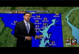
it is clear overhead but look down to the south from jackson, mississippi active tornado warnings, all along the gulf coast states. this will provide us some rain late tonight. warm front, cold front. running into cooler air. temperatures falling into the 30s, 34 new york city. 40s and down to 60 in charleston, south carolina. that is the mild air coming into cold air. that es why maybe some freezing drizzle north and west of town. that is well north and west of the beltway so if you have a commute to the north, just note it could be a slick commute tomorrow morning. rain showers and again ice pellets developing during the morning commute and then warming up. cloudy skies for much of the day tomorrow. then clearing going into tuesday. then another storm system. area of low pressure going from wednesday into valentine's day will develop off the carolina coastline. there are two tracks. that would bring it up to the coast. that would mean some sleet, maybe some snow. this would be wednesday into thursday while the european takes this off shore. this storm will be down to the south and ea
 Live Music Archive
 Librivox Free Audio
 Metropolitan Museum
 Cleveland Museum of Art
 Internet Arcade
 Console Living Room
 Books to Borrow
 Open Library
 TV News
 Understanding 9/11